Why is Earth Observation so expensive - and how does Resoloon fix it?

Earth Observation is supposed to give you visibility over large areas, fast.
In reality, most organizations face the same problem: the data they need either
- comes too late,
- costs too much, or
- doesn’t have enough detail to act on.
If you’re monitoring infrastructure, land, or maritime areas, you’ve likely already run into this.
What You Actually Pay For in Earth Observation
Every current solution forces the same compromise: you can’t have high resolution, large coverage, continuous monitoring, and reasonable cost at the same time.
So teams are forced to choose:
- Either see everything, but too late,
- Or see details, but only in small areas,
- Or pay heavily to try to do both.
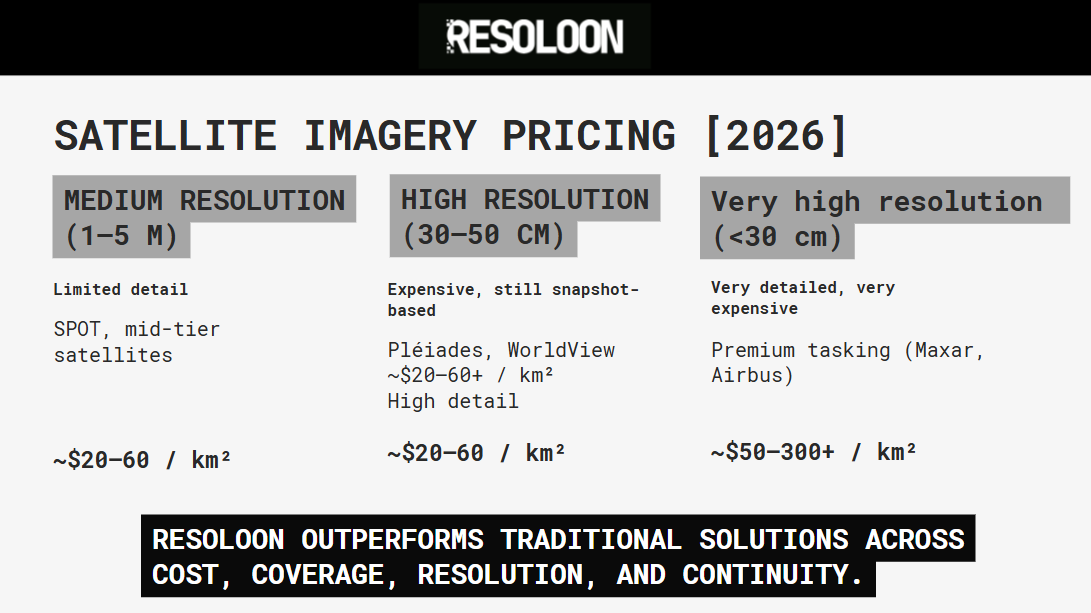
Average cost of satellite imagery in 2026
High-Resolution Earth Intelligence without the Cost & Complexity of Satellites
Resoloon combines high-resolution RGB and infrared imaging to deliver a richer, more complete understanding of the observed area.
By capturing both visual and near-infrared data and merging them into a unified dataset, we enable advanced analysis such as NDVI and GRVI calculations, as well as false-color imagery for deeper insight into environmental conditions.
Our system is designed to handle real-world challenges, including cloud interference, ensuring that the processed data reflects actual ground conditions rather than distorted inputs.
Unlike traditional solutions, Resoloon operates without complex airspace permissions and can be deployed quickly, making it a fast and practical option for large-scale monitoring.
At the same time, the platform is built with efficiency in mind, offering a low-impact, carbon-conscious alternative while still supporting applications such as land assessment and data-driven decision-making.
Built Around Your Use Case
At Resoloon, we take a fundamentally different approach: instead of pricing individual images, we price continuous observation as a service, built around flexibility, transparency, and scalability.
Rather than offering a one-size-fits-all package, our pricing is structured around how you actually use the data.
Several key factors define the final setup:
- The size of the area you want to monitor,
- The level of detail (resolution) required,
- How often you need updates,
- How long the observation should run,
- Whether you need raw imagery or processed insights.
This allows us to adapt the system to your needs - not the other way around.
Our platform turns raw data into actionable outputs - maps, analytics, and insights - so your team can focus on decisions, not data processing.
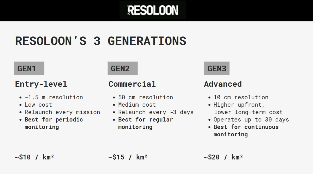
Three Generations, Three Levels of Capability
Our pricing reflects the evolution of our technology, with each generation offering different levels of performance and efficiency.
kép kéne
GEN1 - Entry-Level Monitoring
GEN1 is designed for basic monitoring use cases where cost efficiency is the primary goal. With a resolution of around 1.5 meters, it provides a solid baseline for large-area observation.
Because each mission requires a new launch, this setup is best suited for periodic monitoring rather than continuous operations. It is the most affordable option, both in terms of hardware and operational costs.
GEN2 - Commercial-Grade Observation
GEN2 represents the first fully viable commercial system. With 50 cm resolution, it delivers significantly higher detail while still maintaining large-area coverage.
The system operates in multi-day cycles, typically requiring relaunch every three days. This enables more frequent updates and more consistent monitoring compared to traditional approaches.
It strikes a balance between cost, resolution, and operational flexibility, making it suitable for most real-world use cases.
GEN3 - Continuous, High-Resolution Monitoring
GEN3 is built for long-term, persistent observation. With resolution reaching down to 10 cm and operational duration of up to 30 days, it eliminates the need for frequent redeployment.
This fundamentally changes the economics of monitoring. Instead of paying repeatedly for new data captures, the system stays in place and continuously collects data over time.
As a result, GEN3 enables a level of continuous, high-resolution coverage that is not achievable with traditional platforms at a comparable cost.
Book a Discovery Call
If you are currently evaluating monitoring solutions or struggling with cost, coverage, or update frequency, it is worth exploring what a different approach could look like.
We can walk through your use case, your constraints, and your goals, and outline how a tailored setup would work in practice.
Book a short discovery call
with us to walk through your area, your constraints, and your goals. We’ll tell you honestly whether Resoloon is a good fit - and if it is, we’ll outline a pilot setup tailored to your needs.
Related Posts

Why Earth Observation Is Expensive & How Resoloon Fixes ItQuick introduction
Traditional satellite imagery forces you to choose between cost, coverage, and detail. Resoloon delivers high-resolution monitoring without the tradeoffs.

Why Earth Observation Is Expensive & How Resoloon Fixes ItQuick introduction
Discover how Resoloon made the Forbes 30 Under 30 2026 list. From high-altitude balloons to the Forbes cover, go behind the scenes of our startup journey.